Hello and welcome to a small, preserved piece of the wild
west. Thank you for staying at Old Town Rohnerville. During your stay you might notice the
historic images on the wall but they are not just any old pictures. The photo prints and maps decorating the
space contain the group of buildings you are currently in at different moments
in time.
Back when there was no electricity, indoor plumbing, cars or many other
modern amenities that have brought us further away from the natural world, this
little western town existed as a bustling community. Both opportunity and grit were present from
the gold mines to the farm life that were staple of this little township
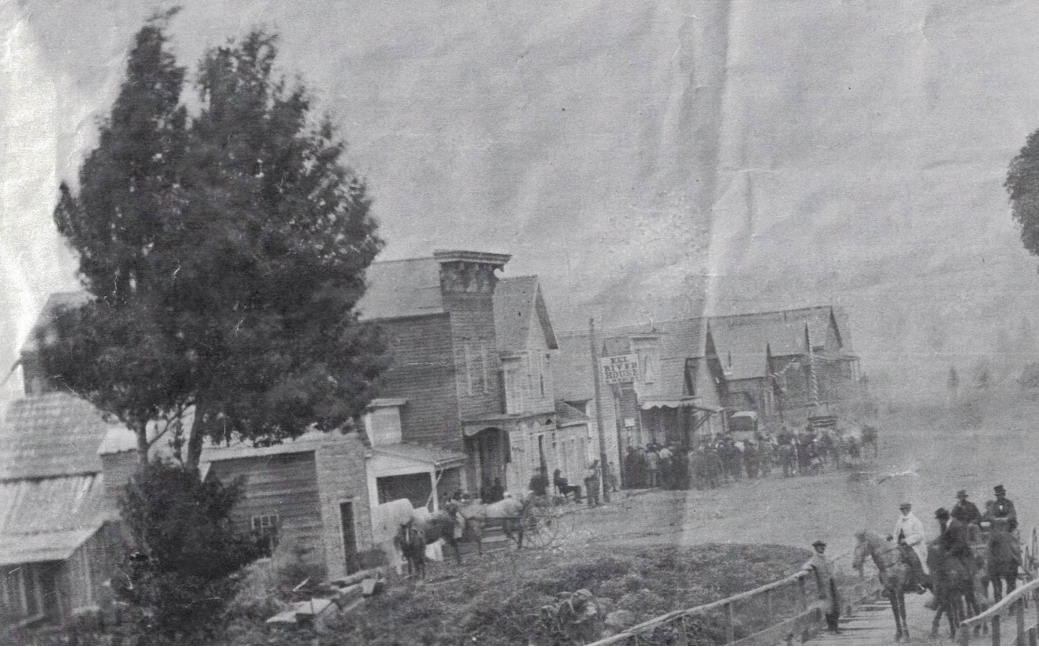
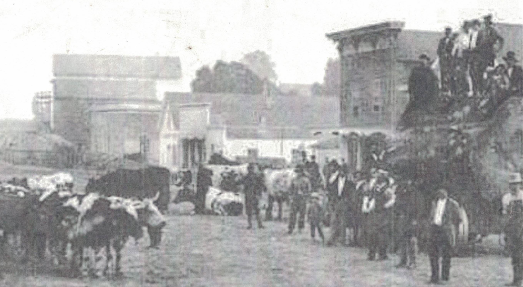
originally named Eel River. The year of
the photo below (Figure 1) was taken is 1875 and life was in full swing right
out side. Much has changed in this part
of town but this small strip of buildings has endured. They have been used and upgraded throughout
generations which in hind site was not always an improvement but it helps you
appreciate the full circle that home styling has completed. The perspective of Figure 1 is katty-corner
to the south east street facing north. It is assumed that they were not yet built till about 1880. While it is not certain, the old building
closest in the foreground could be the red building today which is next door
before it’s facade was added. It is a
long shot but the onus is on anyone who can disprove it...right. Further down the line are saloons,
billiards, masons, hotels, barber, and more.
Sow's Ear from the Rohnerville Rd. Bridge
This photograph in figure 1 shows a bustling town center of
down town Rohnerville. Notice all of the
people standing outside of what is presumed to be the Free Mason’s meeting
hall. Also what could be an early spiral
stripped barber flag can be seen in the background. The row of buildings had all of your old western staples; a saloon, game room, hotels, post office, stable, livery, general store and other business that served the local community. The only transportation was walking and
beasts of burden to get around the dusty streets. The gathering of people had to get there
somehow which sends the eye looking for their method of mobility. On the right of the photo, across the street
was the horse parking. Other interesting things to see are the small child on
the porch to the very right foreground as well as all the top hats were
apparently in style.
List of Post masters ((4))
The documentation gets scarce the further back in time we
explore; but where the history ends, the story begins.
Figure 2: List of Rohnerville Post Masters
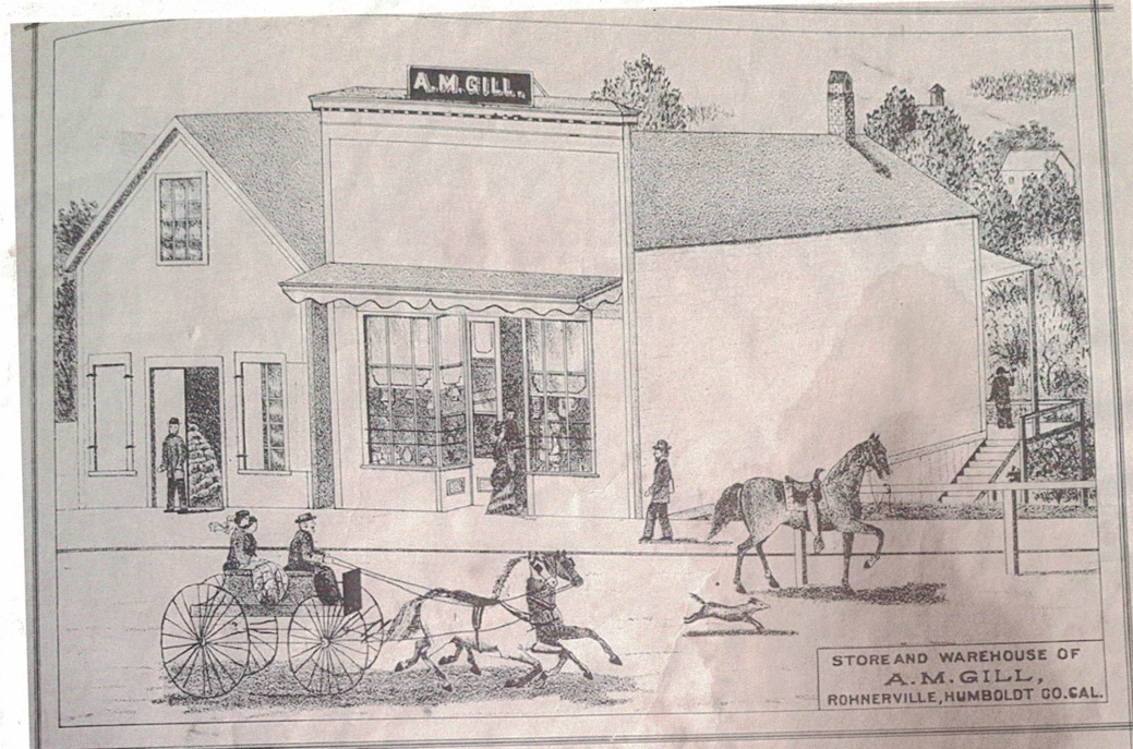
One of the earliest depictions of the center two buildings
is an illustration published in 1881 seen in Figure 3. They stand alone before the buildings on
either side were built ((1)). The single
window on the upper story and the ruffled pattern, cleft in the middle ties
this image to future sightings.
Figure 3: Historic Illustration of The Sow’s Ear 1881
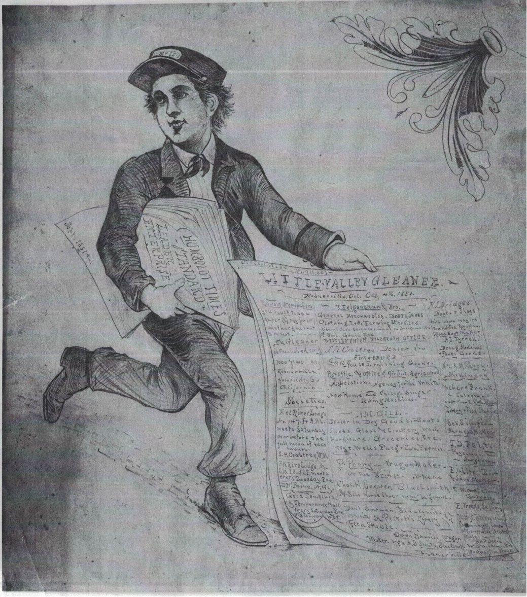
At this time it was the store and warehouse of A. M. Gill:
dealer of dry goods, boots shoes, glass and crockery ware, hardware groceries, etc. You can see the ad for A. M Gill in Figure 4
where it list the items but also lists “Ug’t, wells, Facg + Cu’s. Express”
which doesn’t make sense now but surely did back then.
Figure 4: Old Illustrated Newspaper add 1881
Downtown Rohnerville in Fall of 1880 is shown below in Figure 5 according
to the photo source caption. The
buildings above the ox that is laying down has the ruffles on the awning which is this group of buildings before the orange building to the South was built. To the right is a small building which now is only the living room to the Rohnerville Ranch House.
Figure 5; Buildings in 1880 above where the Ox is laying down.
This picture has captured a view of the wild west, right here, in what was
the main street of Rohnerville, California. Much has changed in this part of town, and most of the amenities that make our lives more comfortable were not even imaginable then, but this small strip of buildings has endured. They have outlived over 5 generations of occupants and endured numerous
modifications, which in hindsight might not always have been considered
improvements. Architectural styles come and go, but these stalwart structures made over a century ago from old growth redwood, still shelter families and friends. If you stand outside on the street and gaze north, you might recreate the scene from this old. See if you can spot the buildings that are still here, minus fancy facades and neighboring businesses. Before, down the road, you’d see all of the happenings of a small western town. Now it's mostly neighborhood with the exception of the oldest commercial buildings around.
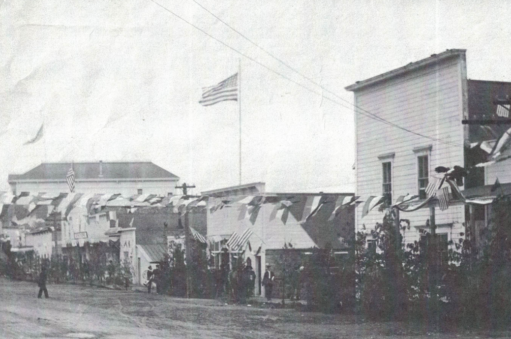
Downtown Rohnerville July 4 1913 is shown in Figure 6 below. The patriotism is on full display complete with flags that cross over the street and high overhead.
Figure 6: Downtown Rohnerville July 4th 1913
To summarize some of the uses of the existing buildings
looking in from the street are as follows.
The orange building to the south with four windows facing
the street was once a furniture, wall paper and paints shop; that was in the
year 1900 ((2)).
The North most building with the wood shingle facade cap was a dwelling in the living room and back bedroom. The kitchen was a separate building at the time which served as a professional office. Independently, the two haves of the building were several retail ventures over the years. In 1909 the North end kitchen was a building that housed a candle and cigar shop. The living room was vacant
building. The South end building became part of the General Merchandise Store of the center buildings.
The middle two buildings were originally separate
businesses. A General goods and
groceries Store to the right and a post office and hardware store to the left.
Both served the locals as well as the wagon trains headed out to the Mad River
gold mines.
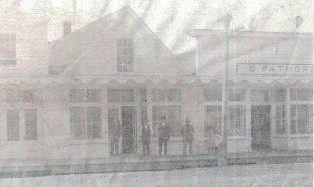
G. Patmore got ahold of the this track of buildings as well
as a few more across the street and ran a prosperous business supplying goods
to the town. The Patmore’s success lasted for about one generation then there
family passed the buildings on. Notice
the single upstairs window along with the awning decorative ruffle with the
cleft in the middle shown in Figure 7.
It is the same buildings owned by A.M. Gill seen in the illustrated
picture in Figure 3 above. Now there is
the orange building, added to the left.
With the presence of electrical wires it is deduced that this photo was
taken after 1896.
Figure 7: Old store buildings without facade on left
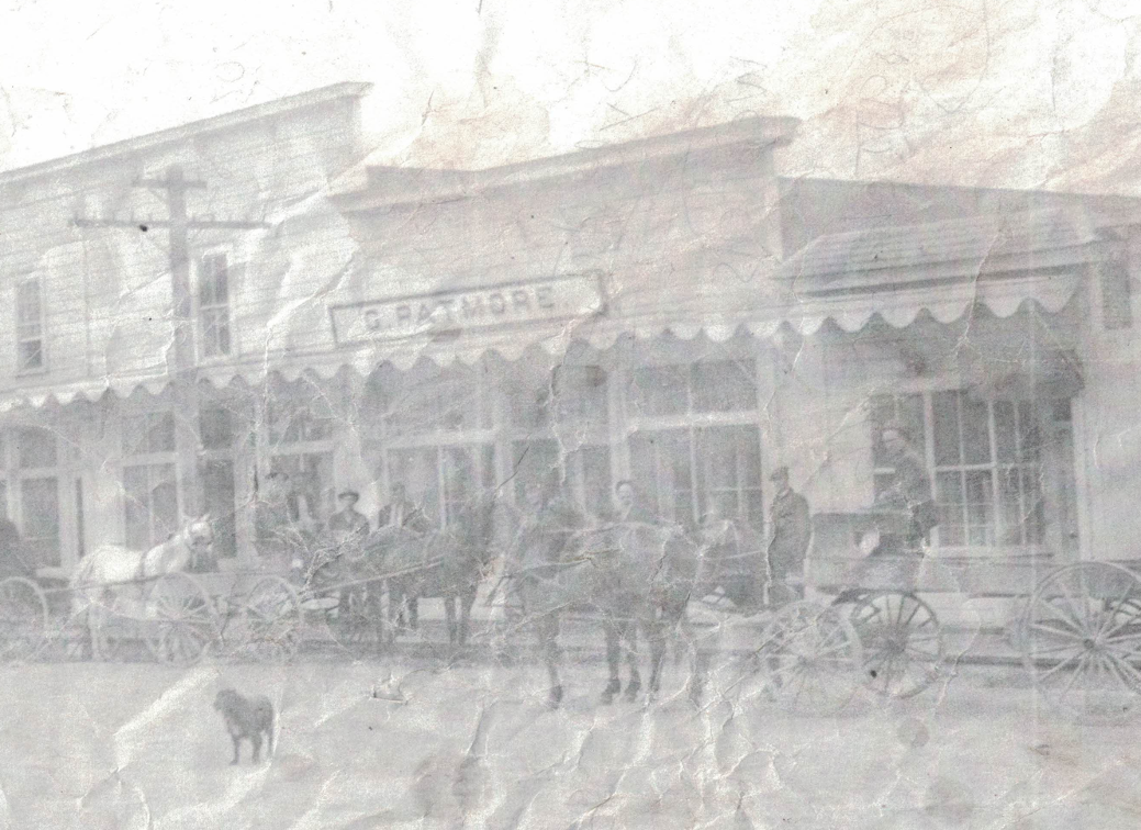
Soon after this picture was taken, a facade was added to the building with one
upper story window, which has remained to the present day show, as shown in Figure
8.
Figure 8: General store buildings with facade added at left
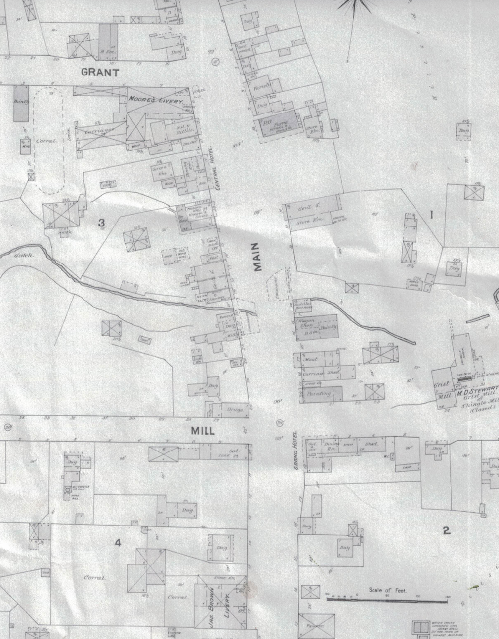
Across the creek to the south was a Barber, Post Office and a Drug store shown in Figure 9 just south of the creek. Now only an empty lot remains. The creek and lot can be seen from the back of the orange building today.
Figure 9: Map of the neighborhood 1889
Notice, if you will, the density and
amount of buildings at the south intersection of Grant and Main in Figure 10. Then you can see the absence of buildings in the same, formerly heavily
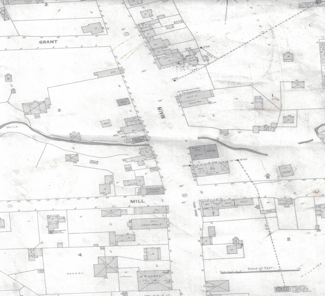
developed intersection. This discrepancy is the result of a fire that swept through in 1905 which was started at Moors Livery and Stable and burned most of the town right up to the current buildings standing. The northern most building with the shingle roof cap was spared thanks to the yard to the north acting as a fire break. The sparse buildings that can be seen on the map in figure are not original with respect to just five years earlier. The fire that started on the corner of the busy intersection burned down many businesses and we owe the powers that be who saved this little cluster of structures by the creek.
Figure 10: Post-Fire map of the neighborhood
Thank you for participating in the history of this old western. If these walls could talk there would be generations of dealings, drama, and happy moments for those who listen. The story is not over for these places as every day the legacy lives on.
((1)) History of Humboldt County California with
Illustrations Descriptive of its Scenery, Farms, Residences, Public Buildings,
Factories, Hotels, Business Houses, Schools, Churches, Etc.From Original Drawings Including Biographical Sketches.
Wallace W. Elliot &Co, Publishers. 106 Leidesdorff Street. San Francisco,
Cal. 1881.
((2)) Sanborn Perris Map Co., Library of Congress 7452
((3)) online timeline. Humboldt History